 |
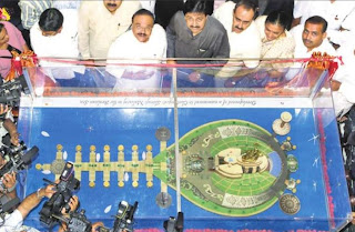
| Shivaji Memorial - Image via 20twentytwo.blogspot.in |
Let’s first build a memorial for Shivaji in our hearts and let it manifest in a number of meaningful causes before building a 300 ft statue in the sea.
You can read the detail proposal here.
 |
| Shivaji Memorial - Image via 20twentytwo.blogspot.in |
 This is another project from Ahmedabad worth mentioning. Until some years back, the Sabarmati River in Ahmedabad was plagued by problems similar to other rivers passing through cities in India today. Untreated sewage disposal, squatter settlements, and flooding during the monsoons were some of them. In 1997 Ahmedabad Municipal Corporation formed the Sabarmati Riverfront Development Corporation Ltd. for the purpose of ‘reviving the city by reconnecting it to the river’. Environmental Planning Collaborative, an Ahmedabad based non-profit headed by Ar. Bimal Patel prepared feasibility studies and proposed a design. Despite unending controversies, the plan can be seen coming to fruition today. The leaders and decision makers of the time are largely to praise for the successful implementation without compromising for quality.
  |
| People throng the riverfront during Kite Festival - Jan 2012 |
 |
| Artists rendering of the promenade |
 |
| Large parks along the riverfront |
 |
| Mula and Mutha rivers - Pune |
 |
| Open land along the river |
 |
| Open land and road as seen from the Omkareshwar bridge. |
 |
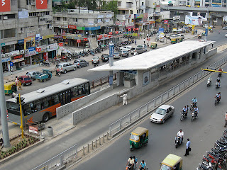
Ahmedabad BRTS. Source: www.flickr.com Photo by Chris Kost
|
 |
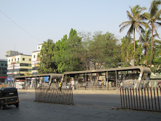
Broken lane barricades - Satara road, Pune
|
 |
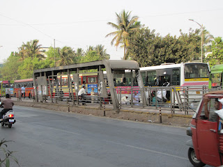
BRT stations are in a bad shape
|
 |
Lack of same level boarding
|
Wow! I just heard that Pune is the fastest growing city in India. It has the largest number of construction sites and one of the biggest migration rates. The McKinsey report (http://www.mckinsey.com/mgi/publications/india_urbanization/executive_summary.asp ) predicts that by the year 2030, Pune will be the fourth largest city in the country following Mumbai, Delhi, and Kolkata, and beating Bangalore, Hyderabad, and Ahmedabad. This means a big deal to us architects, planners and entrepreneurs. Pune is going to witness an unprecedented demand for housing, transportation, quality open spaces, and virtually every other aspect associated with a rapidly developing city. The question is are we prepared for it? As of now the answer is “No”.
There does not seem to be a clear agenda, or a master plan/general plan to address this kind of growth. And if there is one, it is certainly not public. One of the main interests in democratic society is that such plans which are going to affect the lives of the current and future residents should be easily available to the public. A comprehensive general plan and for that matter a regional plan for Pune and its context in the western Maharashtra with other cities of Mumbai, Nashik etc need to be prepared. It should plan and propose for the growth happening within next 50 years. Pune-Mumbai- Nashik could be classified as one giant economic megaregion due to its growing economy, population and physical connectivity.
A creation of a general plan is a big venture. It is a big investment for the city but if done properly it can pay off big time for the future generations. Most of the beautiful and livable urban areas around the planet are not mere creations of chance but long term planning and more importantly proper implementation of those plans. Justifying the need of future growth the a city like Pune can get control over the state owned land much ahead of time for public facilities such as parks, open spaces, public structures like water treatment plants, sewage treatment plants, additional municipal facilities and so on and also allocate land for hospitals, schools, old age homes etc. Predicting and planning for population densities in various parts of the city can help design an efficient public transportation system which is backbone of any well functioning city. The PMC website states that the city is in the process of including 13 villages in its jurisdictions but does not talk of a combined comprehensive plans for these new areas or the old existing ones. The material available online is in bits and pieces and hard to read. I am sure there is some plan and people of Pune would be interested to know what it is how it is going to develop in the coming years, but no effort has been made to make this easily understandable and available for the general public. Similar is the story with many other cities in India.
For the longest time, lack of money, bureaucracy and the 'developing' status of our country has been blamed as a cause for these problems. The common public needs to take a very active part in shaping their urban environment and their role cannot be denied. It is indeed a difficult task but certainly not impossible especially in Pune with its highly skilled technical labor and the influx of money.
Planning documents look ahead in to time and give precise guidelines for the way we want to see our city in the future. The common public should be involved in these decisions and should be made aware of what the city government is planning for in the coming years and how it plans to tackle the current and future issues. This could be done through public exhibitions and published documents.
So in short, we visualize how we want our city to look and be in say the next thirty years and create a plan for that today. Amidst all the political and bureaucratic change these documents serve as guidelines for the future development of the city. All the new developments have to follow the planning guidelines for the city. Thus the general plan for a city serves as an umbrella document for future developments.
This general plan can be broken down in to several categories. There could a preservation plan for the old town and buildings, open spaces and parks plan, plan for central business district, green belts and so on..
The main general plan of the city sets up broad goals and gives an overall direction for the city. It introduces the different elements/plans as mentioned above and outlines their scope. So for instance, a general master plan for the city would talk about the different parks present in the city but would not talk about a proposal for an individual park. Thus creating a general master plan is not the end. This calls up for a task to create a number of other plans such as the ones mentioned in the previous paragraph.
The only overriding plan for the general plan can be the regional plan. To ensure that all these different plans are congruent to one another from the very beginning it is important to convert them into legal documents which are passed and approved by the city. Also it is very important to have a clearly defined time-line for these plans. General master plans usually have a broad time line of 25-30 years. Obviously a lot changes in this time and all the goals and visions set forth in the plan are not one hundred percent realized but still if implemented properly, it is possible to go quite near the visions. Most importantly, the master plan ensures that unintended consequences in the development are curtailed and there is a common organization and alignment of both public and political interests.
This is literally a topic of books but I have tried my best to summarize the idea and importance of a general master plan. USA has a very standardized top-down hierarchy for such plans. There are regional plans, followed by general plans (or the master plan for a city), and then a master plan for individual elements within the general plan such as the downtown, open space and parks, environmental and so on. These individual plans could be further broken down in to small community scale plans, urban design projects and the individual buildings. Not to forget there is also a as built or existing land use plan which acts as a main reference between the present and the future general plan.
Check out some links below to get an idea of how a general plan can look like.
City of Tempe, AZ, USA - http://www.tempe.gov/generalplan/
City of Los Angeles, CA, USA - http://planning.lacity.org/cwd/gnlpln/index.htm